GPS Offline Maps & Navigation
- 3.9
- Rating
- 5.00M
- Installs
- Free
- Price
 Analysis by App-foxy
I tested GPS Offline Maps & Navigation as a practical travel and local-navigation tool, paying particular attention to how comfortably it works for people with different abilities and in different surroundings. My impression is that it aims to cover the essentials in one place: route guidance, traffic awareness, transit information, weather updates, and offline map use. That combination makes it more interesting than a basic map viewer, especially when a journey moves between a familiar city street, a crowded station, and an area with unreliable mobile service.
The app is free to download, belongs to the Travel & Local category, and is made by RCSTUDIOAPPS. It has built a sizeable audience, with over five million installs and a 4.5 average from around fifteen thousand ratings. Those figures suggest that many people find the general concept useful, although popularity alone does not tell me whether it will suit a particular accessibility need. In my experience, the more important question is how much information you can comfortably process while moving, driving, walking, or trying to conserve attention.
How clearly the app presents a journey
The strongest part of the experience is the way the app brings several travel concerns together. Instead of switching between a navigation tool, a transit reference, a traffic screen, and a weather app, I can approach a trip from one travel-focused interface. That matters when the problem is not simply “where am I?” but “what is the safest and least stressful way to continue from here?”
You May Also Like

 Blood Strike: 2.5 Anniversary
Blood Strike’s Loadouts Turn Every Drop Into a Tactical Gamble
A close look at Blood Strike’s custom loadouts: how fast access to signature weapons reshapes its battle royale rhythm, rewards preparation, and narrows the gap between fights.

 Pandora - Music & Podcasts
Pandora’s Music Is Easy to Start, but Harder to Recover
Pandora’s strength is its low-effort path from a seed to a station. Its weak spot is how much confidence it asks you to place in connection, setup, and quiet recovery.

 8 Ball Pool
 Is Built on Rivalries, Rematches, and Routine
A close look at the rivalries, rematches, shared routines, and unanswered safety questions that turn a quick pool match into a persistent mobile community.

 Samsung Music
’s Quiet Strength Is Playing What You Already Own
Its reach comes less from spectacle than from dependable access to a personal library. That simplicity is both the app’s strongest retention engine and its ceiling.

 AccuWeather: Weather Radar
AccuWeather Review: A Quick, Clear Forecast for Everyday Decisions
For everyday plans, the best forecast is the one you can understand quickly. AccuWeather makes rain timing, radar, and local conditions easy to act on, with a few trade-offs.

 Hill Climb Racing
Why Hill Climb Racing Still Turns Crashes Into One More Run
A tiny car, a bumpy hill and one more upgrade: Hill Climb Racing keeps resurfacing because its simple chaos makes every near-miss feel personal.
More From Our News Desk
View All News


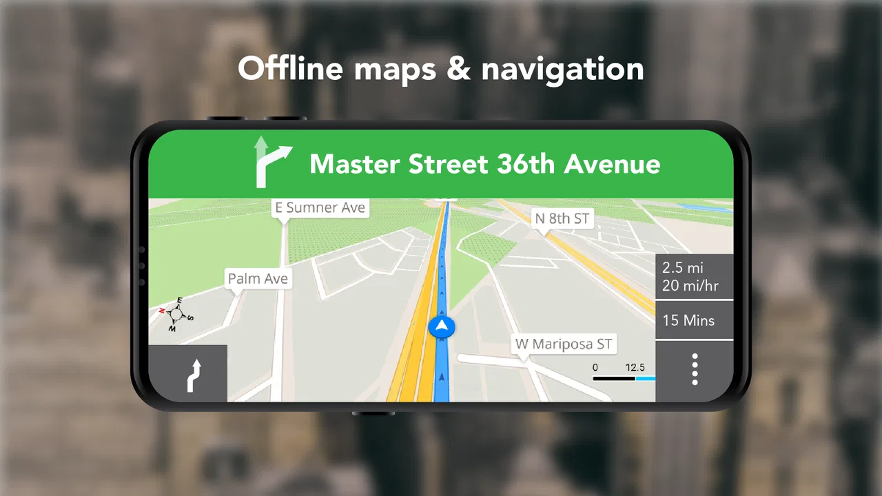
For someone with limited vision, readable route information is more useful than a crowded display full of decorative detail. Offline maps can help reduce dependence on a live connection, while turn-by-turn guidance offers a more direct way to follow a route than repeatedly checking a map. I would still recommend setting up the route before starting, because reading a screen while walking or driving is a poor substitute for preparing in advance.
The short description presents the app as GPS offline maps, but the broader experience is not limited to static maps. Traffic, transit, and weather updates give the journey more context. That can be valuable for a user who needs to make fewer decisions on the move. For example, checking weather before leaving may help someone who is sensitive to heat, rain, glare, or sudden changes in outdoor conditions choose a better departure time.
There is also a useful distinction between seeing a route and understanding it. A map can show a line, but a traveler may need to know when to prepare for the next turn, whether the trip depends on public transport, or whether conditions could make the route uncomfortable. The app’s combination of navigation and updates is promising for that broader planning task. I found it more useful when treated as a preparation tool rather than something to open only after becoming lost.
Preparing routes before attention becomes limited
One practical habit I recommend is checking the complete journey while you still have time and a stable connection. Look at the route, review the transit portion if one is involved, and consider the weather before leaving. This workflow is especially helpful for people who experience fatigue, anxiety, cognitive overload, or difficulty switching between tasks. It also benefits anyone traveling with a child, an older relative, or luggage.
Offline map support can be particularly reassuring in underground stations, rural areas, or places where a signal becomes inconsistent. It should not be treated as a guarantee that every live update will remain available without connectivity: traffic, transit changes, and weather information are time-sensitive. The sensible approach is to use offline mapping for the geographic reference and check live information before entering a low-signal area.
That separation between stable and changing information is one of the less obvious ways to use the app well. A saved or available map can help with orientation, while current conditions still deserve a deliberate check. Users who assume that an offline map automatically replaces every online service may be disappointed. Users who understand the difference can make the app a useful backup instead of relying on it blindly.
Readability while walking, riding, or driving
Turn-by-turn guidance can reduce the need to interpret a full map continuously, which is helpful when visual attention is limited. It may also be easier for people who find dense map screens tiring. On the other hand, navigation is only as accessible as the route instructions and the user’s ability to notice them. A person who cannot comfortably read small labels, distinguish map colors, or operate a phone while moving should plan around those limits rather than expecting the app to solve them.
I would use the app with the phone positioned where it can be checked safely and without blocking the view while driving. For walking, I would review the next stage before crossing a busy area or entering a station. These are simple choices, but they reduce the need for rushed gestures and make the experience more manageable for users who need extra time to interpret directions.
The app runs on devices using at least Android version nine, and the current version is 2.01. That makes compatibility an important first check for anyone using an older phone or a device with limited performance. A compatible operating system does not automatically mean an identical experience on every screen size, so people who depend on large text, magnification, or a particular system setting should test the interface during a calm trip before trusting it for an unfamiliar journey.
Motor, sensory, and situational access
Navigation apps can create a surprising amount of physical work. A user may need to hold a phone, tap small controls, zoom a map, dismiss information, and switch between route views. For someone with tremors, reduced dexterity, joint pain, or only one free hand, that can become more difficult than the map itself. My advice is to do as much route preparation as possible before departure and avoid making frequent changes while moving.
GPS Offline Maps & Navigation is most comfortable when the journey is treated as a sequence of planned checkpoints rather than a constant stream of screen interaction. Before leaving, I would identify the overall destination, confirm whether transit is involved, and check the weather. During the trip, I would use the guidance as confirmation rather than repeatedly rebuilding the route. This reduces taps and lowers the chance of an accidental change at an inconvenient moment.
People with sensory sensitivities may appreciate the possibility of limiting unnecessary decision-making by preparing offline map information in advance. A crowded screen, changing traffic notices, and several travel conditions presented together can also feel overwhelming, however. The app’s breadth is a strength for planning, but it can become a weakness when a user needs only one clear instruction at a time.
For that reason, I would not judge the app only by how many travel details it presents. The better test is whether the user can create a calm routine around it. Someone who benefits from a written itinerary, a trusted companion, or a familiar sequence of checks may find the app fits nicely into that routine. Someone who needs a very minimal interface with no extra travel context may prefer a simpler navigation option.
Public transport and changing environments
Transit information gives the app a useful role beyond car navigation. A trip may begin on foot, continue by bus or rail, and finish with another walk. That mixed journey is exactly where a single-purpose driving navigator can feel incomplete. I would use this app to understand the shape of the trip before leaving, especially when weather or traffic could affect the walking portions.
There is a trade-off for users with mobility limitations. A transit route may appear efficient on a map but still be difficult if it involves long walks, stairs, crowded platforms, or hurried transfers. The app can help organize the route, but it should not be assumed to know every personal access requirement or the real-time condition of every path. If step-free access, seating, quiet spaces, or extra transfer time are essential, I would verify those details separately before committing to the journey.
This is also where situational access matters. A person who normally reads a map easily may struggle in rain, glare, darkness, or a noisy station. A traveler with hearing loss may need to rely more heavily on visual information, while a traveler with low vision may need a larger, simpler presentation or assistance from another person. The app can be part of the solution, but it cannot replace a travel plan designed around the individual.
Weather and traffic as accessibility information
Weather updates are not merely a convenience. They can influence whether a route is usable for someone with chronic pain, balance concerns, respiratory sensitivity, or difficulty regulating body temperature. Rain can make a pavement harder to navigate; heat can turn a short walk into a serious burden; poor conditions can increase the need for breaks. Checking the forecast before leaving is one of the most practical ways to use the app for inclusive travel planning.
Traffic information has a similar value for people who need extra time or prefer calmer roads. Avoiding a congested area may reduce stress, noise, and crossing difficulty, even if the alternative route takes longer. I would not automatically choose the fastest suggestion. For many users, a route with fewer complicated decisions is better than one that saves a small amount of time.
That is an important trade-off when comparing this app with the usual alternatives. A dedicated map service may offer a more familiar interface or deeper place information, while a dedicated weather app may provide more specialized forecasts. This app’s advantage is the travel-oriented combination. Its limitation is that combining several kinds of information can require more attention than a focused tool. I would choose it when I want one planning companion, not when I need the most specialized experience in every individual category.
Where the experience still has barriers
The app should not be treated as universally accessible simply because it includes offline maps and several travel modes. Those features address connectivity and planning, but accessibility also depends on typography, contrast, control size, spoken guidance, route detail, and compatibility with the user’s preferred assistive setup. I would test those elements personally before using it for a high-stakes trip.
Another barrier is the difference between technical navigation and real-world navigation. A route can be accurate in geographic terms while still being uncomfortable or impractical for a wheelchair user, someone using a cane, a person who cannot climb stairs, or anyone who needs frequent rest. The app may help identify where to go, but the traveler still needs to judge whether the path matches their body, energy, and equipment.
Live information also creates a timing issue. Traffic, transit, and weather change, so an offline map is not a complete substitute for current information. I would download or prepare the map before departure, then check the changing parts immediately before setting out. If the trip is long, I would keep a backup plan and avoid depending on a single phone for every decision.
There is also a financial point worth noticing. The app is free, but optional in-app purchases range from around nine dollars to about one hundred fifty dollars per item. That does not make the basic download paid, but it does mean users should review purchase screens carefully and decide whether any optional upgrade is genuinely useful for their needs. For someone choosing an app specifically because a free tool is important, that distinction matters.
The Everyone content rating makes the app suitable for a broad audience in terms of age classification. That does not remove the need for supervision or planning when a child is navigating, nor does it tell me whether the interface will suit a particular disability. A young traveler may still need an adult to prepare the route, and an older traveler may need a simpler routine than the rating suggests.
Who will benefit most from this approach
I think the app is a good fit for travelers who want offline map support but also care about traffic, transit, and weather when planning a route. It is especially useful for someone who moves between walking and public transport, travels through areas with uncertain connectivity, or wants to reduce the number of separate apps used before leaving home.
A realistic example would be a commuter visiting an unfamiliar city for an appointment. The commuter can check the forecast, consider traffic, review a transit route, and prepare the map before leaving. If the weather worsens, the route can be reconsidered with the person’s energy and mobility in mind. That is more thoughtful than simply choosing the shortest line between two points.
I would be less likely to recommend it as the only navigation aid for someone who needs guaranteed step-free routing, highly specialized accessibility details, or a very controlled interface with minimal visual information. In those cases, a specialist transit resource, a familiar map service, or assistance from a trusted person may be better. The app can still support the plan, but it should not be the sole authority.
Users who dislike optional purchase prompts should also approach it with awareness. The free entry point is appealing, yet the presence of paid items means the experience may invite decisions beyond simply installing and navigating. I would explore the core workflow first and avoid buying anything until I had a clear reason connected to my own travel habits.
My inclusive verdict after using it
GPS Offline Maps & Navigation is a useful, broad travel app whose accessibility value comes mainly from preparation and reduced app switching. Offline maps can make orientation less dependent on a stable connection, while traffic, transit, and weather information help users think about the whole journey rather than just the next turn. For people with different abilities, that wider planning view can be genuinely helpful.
At the same time, I would not describe it as a complete accessibility solution. It cannot by itself guarantee that a route is step-free, quiet, physically comfortable, or suitable for every sensory need. The best results come from checking the journey early, separating offline map information from live updates, allowing extra time, and keeping a backup when the trip matters.
With its free download, Everyone rating, and broad travel focus, it is easy to try on a compatible device. The developer is RCSTUDIOAPPS, and the app was released on June 27, 2019, with version 2.01 currently available. I would recommend it to readers who want one flexible navigation companion and are willing to adapt the workflow to their own needs. My main recommendation is to use it as a planning aid first and a last-minute rescue tool second. That approach brings out its strongest qualities while keeping its remaining barriers in view.
FAQs for GPS Offline Maps & Navigation
01How accurate are the maps in GPS Offline Maps & Navigation?
The accuracy of GPS Offline Maps & Navigation is generally high, as it uses regularly updated data from reputable sources. However, the precision can vary depending on the region and infrastructure changes. It's advisable to download the latest map updates before traveling to ensure the best accuracy.
02Does GPS Offline Maps & Navigation require an internet connection?
One of the app’s key features is its ability to function without an internet connection. You need to download the maps for your desired regions while online, but once downloaded, the app uses GPS to provide navigation and map details offline, saving data costs.
03What are the main features of GPS Offline Maps & Navigation?
The app offers a range of features including turn-by-turn navigation, voice instructions, offline search, points of interest, route planning, and real-time traffic updates (when online). These features make it a comprehensive tool for travelers who need reliable navigation without relying on data services.
04Is GPS Offline Maps & Navigation user-friendly for beginners?
Yes, the app is designed with a user-friendly interface that is accessible to beginners. It provides intuitive controls and clear instructions. The initial setup involves selecting and downloading maps, but once this is done, navigation and other functions are straightforward and easy to use.
05How much storage space do I need for the map downloads?
The amount of storage space required depends on the size and number of maps you download. Larger regions or countries will require more space. On average, a country map might take between 100MB to 500MB. Ensure your device has sufficient storage before downloading multiple maps.
Pros
- No internet needed for navigation.
- Detailed maps with regular updates.
- Customizable routes and waypoints.
- User-friendly interface for easy use.
- Supports multiple languages.
Cons
- Large app size requires storage space.
- Some features locked behind paywall.
- Limited real-time traffic updates.
- Initial setup can be time-consuming.
- Battery drain on prolonged use.

GPS Offline Maps & Navigation
Gallery